Download sentinel 2 satellite images with spatial resolution 10m

In this course I will show you how to download Sentinel 2 satellite images with a spatial resolution of 10 m from the European Space Agency (ESA) website. The images are free, with spatial resolution 10m.
Sentinel 2 satellites
Sentinel 2 satellites, launched as part of the European Commission’s Copernicus program on June 23, 2015, was designed specifically to deliver a wealth of data and imagery. The satellite is equipped with an opto-electronic multispectral sensor (MSI) for surveying with a sentinel 2 resolution of 10 to 60 m in the visible, near infrared (NIR), and short-wave infrared (SWIR) spectral zones, including 13 spectral bands, which ensures the capture of differences in vegetation state, including temporal changes, and also minimizes impact on the quality of atmospheric photography.
The orbit is an average height of 785 km and the presence of two satellites in the mission allow repeated surveys every 5 days at the equator and every 2-3 days at middle latitudes.
The Sentinel 2 data provides GMES (Global Monitoring for Environment and Security) program, jointly implemented by the EC (European Commission) and ESA (European Space Agency) services related, for example, to land management, agricultural production and forestry, and monitoring of natural disasters and humanitarian operations.
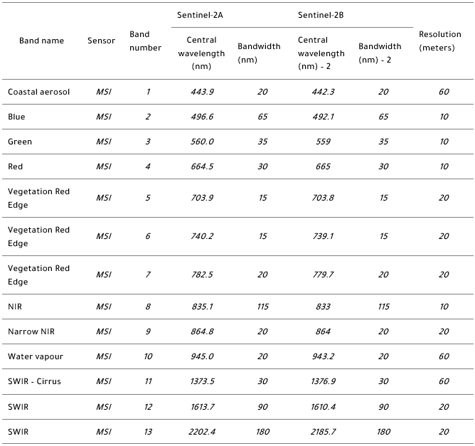
Sentinel 2A and Sentinel 2B Bands
How to download sentinel 2 satellite images with spatial resolution 10m from ESA website?